
|
ED'S OUTDOOR PAGES
(fomerly the Green Mountain Club Montpelier Section website ) |
|
|
Cottonbrook/Little River Valley Moscow, VT October 2, 2005 |
||
|
|
||
|
This was an unusual "hike": No hills, no specified goal, just a rather informal stroll along a pretty creek valley in the terrain exposed by the draining of the Waterbury Reservoir. There is no official trail there, and in fact the trail established by use is considerably more overgrown and somewhat more filled in with soil than last year, although there is some evidence of attempts to repair or maintain the trail in one spot. Trees are starting to grow, evidence of the change in ecology likely to proceed if the valley is not flooded again. |
||
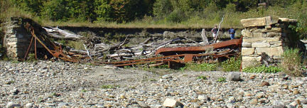
| Dorothy, Beth, Ken, Roger and Ed walked at a leisurely pace about a mile along the stream until we came to the remains of a steel bridge. It is apparently quite old, since the stone pilings appear to be dry-stone, pointed with mortar at some later date. The old water-line of the reservoir is visible about the level of the top of one piling. |
|
|
|
Where
did the bridge go from the piling in the middle of the
"lake"? The water line on the other side is some distance
away.
Before crossing the 4-foot-wide stream at the bridge, we decided to explore an inviting pine glade, which is clearly being used as a campsite, but is clean and free of trash.
|

|
|
| This area was apparently in use when the reservoir was full, since we reached it from what was once the waterline by walking a few feet up a broad, well-established trail. We decided to follow a pine-carpeted trail in the direction of the Cottonbrook road, in the general direction of the historical area of the old abandoned town. We came across the remains of a substantial dry-stone wall that must have been a barn long ago. We met a man walking his dog who informed us that the trail intersected the Cottonbrook Road a short distance ahead, on which one could turn right and reach the parking area about three-quarters of a mile further. At that point, Dorothy announced she had to meet someone at noon, and went jogging off to her appointment. Since she was a runner, new in town and unfamiliar with the trails, and had thought (was hoping) the trip was along the dirt roads above the stream, this was her opportunity to run a short distance on one. | ||
|
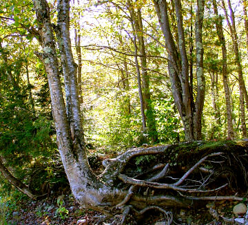
The
rest of us walked the additional mile or so to the end of the narrow
trail, as far as a well-used picnic area on a wide bluff overlooking the
valley. The water must have been quite deep here, since the old high-water
line, just at the level of the picnic area, is many feet above the present
stream bed. This photo show how the water undercut the roots of trees
along the bank. We stopped in the shade for lunch. Ken unwittingly put his pack down on a yellowjacket nest, and got a couple of stings. We moved to the other side of the clearing, and finished lunch. |
|
|
|
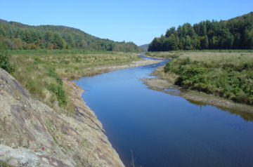
Ken and Beth decided to turn
back after lunch, heading north up the valley along the same path.
Looking north along the stream. The footpath stays pretty close to the water on the west bank. This is actually a very small area: the distances seen are not great at all. |
|
|
|
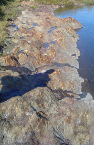
A close-up of the rocks in the
previous photo.
If anyone knows anything about geology and rock formations, please get in touch and tell me what this is. |
|
|
|
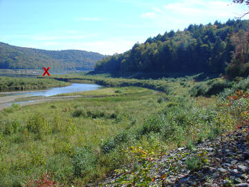
At the "Picnic
Bluff", the trail stops. The area beyond has always been too
swampy to invite passage. Roger and I thought it would be fun to try to
get as close as possible to the bend in the stream, where there is still a
real "lake" near the southern end of the old reservoir.
"X" marks the point at which we turned back. We bushwhacked uphill from the picnic area, thinking it would be drier, struggled through a tangle of downed trees and muck from seeps running into the stream, and finally returned to the stream. The going was actually easier |
|
|
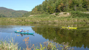
| At the far end of our bushwack, we met some kayakers, and a man in a small motorboat. |
|
|